The Ural River originates in Russia, and flows into the Caspian Sea in Kazakhstan. It is the third longest river in Europe. Its length is 2428 km. According to this indicator in the region, it is second only to the Volga and the Danube. A symbolic bridge was installed over the source of the Urals, allegedly connecting two parts of the mainland: Europe and Asia.
General information
The Ural River until 1775 was called Yaik. After the peasant revolt led by Emelyan Pugachev was strangled, Empress Catherine II renamed the territories engulfed in turmoil by her decree. Bashkir and Yaik Cossacks, who took part in the uprising, have since become known as Ural Cossacks. This was done in order to erase from the memory of the inhabitants the events when power and state control over the territory was lost.
The Ural is a fast river. It flows through landscapes of different nature, forming on its way unique ecological complexes. Its channel is winding along its entire length. Several times the river abruptly changes direction, deviating from the south direction, encountering natural barriers on its way. The climate in the region is mostly continental with strong winds. There is relatively little precipitation - up to 540 mm, which cannot serve as a stable source of water supply.
Mode
The Ural is considered a typical steppe river with uneven total flow. This is especially noticeable in a high-water year. The Urals feed on melting snow cover. It accounts for 65% of the total volume. The rest is precipitation and partly groundwater.
The Urals freezes from November for up to 120 - 160 days, depending on the region. It opens in late March or early April. Ice by the end of winter reaches up to 80 cm in thickness. During the melting of the snow cover, and its peak occurs in the lower reaches in March - April, and until May - June, up to 80% of the total water flow passes in the upper reaches of the Urals.

High water raises the river level from 2.5 m in the upper reaches to 7 m near Uralsk in the lower reaches. The maximum values reach 11 m. In the summer, the Urals are not such a big and stormy river. But during the flood, its width increases in some places up to 20 km with a maximum of 36 km.
channel
The Ural River is considered fast-flowing. From the source to the mouth, the height difference is on average 30 cm per 1 km, which is four times greater than that of the Volga. The speed of the current in the period of high water is often 10 km / h, in low water this figure is half as much.
The average width of the channel in the upper reaches (with the exception of the flood period) is 60 - 100 m, in the lower reaches this figure is twice as large. Coasts with steep cliffs and ravines. The bottom in the upper reaches is rocky, below it is with the inclusion of gravel and pebbles, in the lower reaches it is mostly sandy.
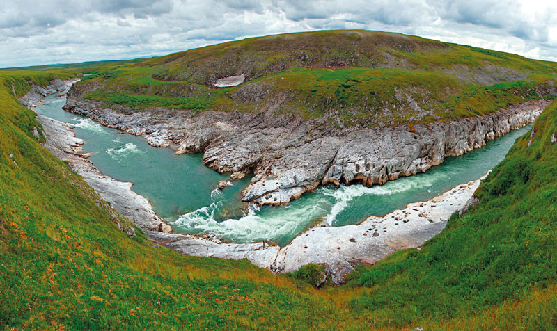
On the segment from Orenburg downstream, there are up to 700 riffles. The depth of the reaches is on average 3 - 4 m, the pits - up to 8 m. Closer to the mouth, 200 km from it, there is the famous Kruglovskaya Prorva. The channel there is very narrow, as a result of which the depth increases, serious whirlpools are created, which in some cases can pose a danger to navigation.

river basin
The Ural River collects water from an area of 231 thousand km². Its pool is located asymmetrically. On the right side, it is two times smaller, although there are just more tributaries in this part. This is due to the nature of the rivers flowing into the Urals from different directions. The right ones are mostly mountain tributaries, and the left ones are mostly flat. Some of them are unstable, and water is brought to the main channel only during high water, and in summer they often dry up.
The largest tributary on the right is the Chagan. Other rivers can be distinguished: Sakmara, Artazym, Taganlyk, Bolshoi Kizil. On the left side, the most full-flowing tributary is the Ilek. In addition to it, the Urals are also fed by rivers: Or, Utva, Chest, Gumbeika, Bolshoi Kumak.
Ural River map
The source is considered to be a spring located in the spurs of the Uraltau ridge. It is located 637 m above sea level at the foot of the Nazhimtau mountains. At first, the current is directed south to the upland of the Kazakh steppe. This barrier causes the river to turn to the northwest.
In this direction, the current drives water to Orenburg, and then again turns southwest to Uralsk. Further downstream, the channel carved its way south. The river meanders slightly, slightly deviates from north to west, but flows to the mouth in a southerly direction and flows into the Caspian Sea.
The Ural originates in Russia. It flows through the territory of Bashkortostan, crosses the Chelyabinsk and Orenburg regions. The upper reaches of the river have a mountainous character up to Verkhneuralsk, then, up to Magnitogorsk itself, it changes to a calmer, flat one. Before Orsk, the channel is compressed by rocky shores, and rifts occur in this interval.

In the middle course, the Ural crosses the border with Kazakhstan. Then he moves south. After the city of Uralsk, stretching along the Caspian lowland, the channel expands, numerous channels, lakes and oxbow lakes are formed. The river flows into the Caspian Sea in two branches.
Russia: Ural river
The source is considered to be a spring spouting from the ground at an altitude of 637 m above sea level. A few years ago, the beginning of the Ural River was marked with a memorial sign. This place is located in Bashkortostan near the village of Voznesenka, Uchalinsky district. Downstream, five small springs merge into one channel, which at this interval has the character of a mountain river. Further, the Ural descends into the valley and flows into the vast Yaitskoye swamp.
To supply the Magnitogorsk Iron and Steel Works, two reservoirs have been built in the upper reaches of the river. There is also a production facility in Orsk that takes water from the Urals. This is the Khalilov Metallurgical Plant.

River in Kazakhstan
The mouth of the Ural River is located in Kazakhstan below the city of Atyrau. It is located 27 m below sea level. Thus, the height difference from the source is 664 meters. The mouth is arranged like a delta. It is finger-shaped. This is typical for most rivers flowing into inland seas and having a low flow rate in the lower reaches. The Ural flows into the Caspian in two branches: Yaitsky and Zolotinsky. The beginning of the delta is considered to be the place of departure of the Narynka channel, which is 100 km from the mouth.
Shipping is possible to Uralsk. A reservoir was built downstream and the Kushumsky Canal originates. A port has been built in Atyrau. Developed fishing. Bream, carp, herring and sturgeon - these fish are considered commercial in the region. Agriculture is developing, with emphasis on the cultivation of melons and watermelons. The water of the Urals is used for irrigation, dozens of canals are equipped. The river is of great economic importance, it is interesting for tourism and outdoor recreation.
Ural, or Yaik - a river flowing through the territories of Russia and Kazakhstan. This is the third longest water flow in Europe (the Volga and Danube are the leaders in this indicator). Its length is 2428 km, and the basin area is 231 thousand square meters. km. The Ural is a river flowing into the Caspian Sea. Its source is located on the Uraltau ridge in Bashkortostan.
When was the Yaik River renamed Ural?
This happened in 1775, after the Peasant War was suppressed, the leader of which was E. Pugacheva. Yaik Kazakhs and Bashkirs actively participated in this war. What the Yaik River is now called is the merit of Catherine II - it was she who issued a decree on renaming the water stream in order to erase any memories of the uprising.
In general, for the first time the name Yaik was mentioned in Russian chronicles in 1140, and the ancient name of the river, according to Ptolemy's map, sounds like Daix. This word of Turkic origin means "wide", "spread".
Geography
As already mentioned, the Ural (Yaik) River originates in Bashkiria, on the slope of the Round Hill of the Uraltau Ridge. At first, the water flow flows from north to south, and then, having met the plateau of the Kazakh steppe on the way, it turns to the northwest. Further, beyond Orenburg, the direction becomes south-western, and near the city of Uralsk, the river again bends to the south. In this southerly direction, meandering now to the east, now to the west, the Ural flows all the way to the Caspian Sea.

The water fall in the river is not very large: from the upper reaches to the city of Orsk - 0.9 m per 1 km, from Orsk to Uralsk - 30 cm per 1 km, and even less below. The channel width is insignificant, but varied. In the upper reaches, the bottom of the Urals is rocky, under the Urals it is lined with small pebbles, while in the rest of the bottom, as a rule, it is sandy and clayey.
The current is quite winding, forming many loops. With a small fall in water, the river often changes its main channel throughout its length, digs new passages, leaving oxbow lakes (deep reservoirs) in all directions. Due to such a changeable current, at one time many Cossack settlements were forced to move to other places, since their dwellings were gradually undermined and demolished by water.
The climate in the region is mostly continental, with characteristic strong winds. Precipitation is relatively low, no more than 540 millimeters per year, so the river lacks a stable source of water supply.

Between Europe and Asia
Not everyone knows that the Ural (Yaik) is a river that is a natural border between two parts of the world. Geographically, in Russia the border runs in the Chelyabinsk region, in the cities of Magnitogorsk and Verkhneuralsk, and in Kazakhstan - along the Mugodzhary ridge. The Urals are inland European, only the upper reaches east of the Ural Range can be attributed to Asia.
However, there is another opinion on this matter. In 2010, in Kazakhstan, in the Ustryut desert, an expedition of the Russian Geographical Society was carried out. The results showed that the Ural River does not divide anything, since it crosses an identical area, and drawing the border between Europe and Asia along it is unreasonable from a scientific point of view. The fact is that to the south of the city of Zlatoust, the Ural Range loses its axis and falls apart. Then the mountains gradually and completely disappear, thus, the main landmark for drawing the border disappears.

Shipping
Previously, the river was navigable up to Orenburg. During the Soviet Union, water transport ran between Uralsk and Orenburg. However, as a result of constant changes in natural conditions (destruction of forests, plowing of steppes), the Urals became much shallower, and this process continues to this day. Every year ecological expeditions are held here, options for saving the river are discussed. But while the Urals are getting shallow, so now it is not very navigable.
Monuments of nature
Ah, how beautiful the Urals (Yaik)! The river abounds in landscape and geological natural monuments. The most famous of them:
1. Tract White stone. This unique formation is located on the left bank, near the village of Yangelskoye, and is a rock outcrop of limestone, which was formed 350 million years ago, during the Carboniferous period. Rare species of lichens, animals and plants, remains of fossil organisms are found here.
2. Mount Izvoz. It is located on the right bank, three kilometers from Verkhneuralsk. This botanical monument is interesting for its picturesque rocky outcrops, man-made pine plantations and artificial park structures.
There are other equally beautiful monuments: the Orsk Gate, the Maiden's Mountain, the Nikolsky section, the Iriklinskoye Gorge.
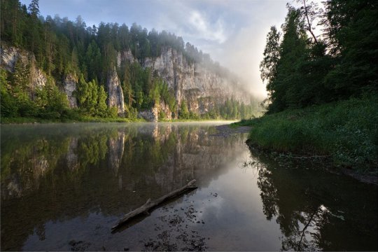
The most picturesque section of the river begins below the city of Orsk, where it flows through the gorge of the Guberlinsky Mountains. Tourist rafting is often organized here.

Fishing
Ural (Yaik) is a river rich in fish: pike perch, sturgeon, catfish, roach, stellate sturgeon, bream, carp, pike, vobla, crucian carp, dace and many other vertebrates are found here. In past centuries, the Urals was famous for its sturgeon species, they even say that in the 1970s 33% of the world's sturgeon production was caught on the river. Now such a fish has become a rarity here, but all the same - fishing in the Urals is good, hardly any fisherman will be left without a catch!
It is believed that during the Civil War he drowned in the waves of the Urals (although there are many versions of his death to this day, and it is not known for certain which of them is true).
Several reservoirs have been created on the river. The largest is Iriklinskoye.
The Ural is a fast-flowing river, during the period of full water the speed of the current reaches 10 km / h.
The source of the Urals is a spring gushing from the ground at an altitude of 637 meters above sea level. This place is marked with a memorial sign.
The Urals is simply dotted with numerous and beautiful rivers with clear cold water and picturesque rocky shores, and the most interesting rapids and rifts make them extremely attractive for outdoor activities. Mysterious rocks, keeping many traditions and legends, are surrounded by endless taiga. Bones of unseen animals, precious stones, gold, unknown rock paintings have been found here more than once ... The waterways of the Urals are mysterious and attractive, we will talk about several of them.
Ural mountains
First of all, we should talk about these mysterious mountains. The Ural Range stretches for two and a half thousand kilometers, from the icy shores of the northernmost ocean to the hot semi-deserts of the Republic of Kazakhstan, being the watershed of many rivers of the eastern and western slopes, the real border of the worlds of Asia and Europe. The ridge also separates the Russian and West Siberian plains. Rivers and are very numerous and have their own interesting features. There are more than five thousand rivers here, belonging to the basins: the Kara Sea, the Barents Sea, the Caspian Sea.
An interesting feature of this region is a large number of artificial reservoirs - reservoirs, as well as ponds (more than three hundred with a total area of about 4.2 thousand square kilometers). Together with numerous hydroelectric power stations, the bulk of artificial reservoirs are part of the hydrotechnical plant network of the Urals.
Natural and climatic features
The huge length of the mountain range creates extremely diverse natural and climatic conditions for the rivers and lakes of the Urals, which inevitably affects their features.
The climate of the region is continental, with cold snowy winters and warm summers. The northern part of the Urals experiences a strong climatic influence of the northern seas and the Arctic Ocean, while the middle part of the mountain range is in the zone of influence of the Atlantic (especially the western part, where the greatest amount of precipitation is recorded). The steppe and forest-steppe zones of the Ural Mountains are characterized by insufficient moisture, which directly affects the water abundance of the rivers flowing here, while the taiga and tundra zones, on the contrary, are characterized by excessive moisture.
in different parts of the Urals
In the Polar Urals, a small number of high-water rivers begin their run, such as the Khara - Matalou, Sob, Yelets and others.
Rapids, fast and large rivers of the Urals flow in the Northern and Subpolar parts of the mountains, such as the Pechora and its numerous tributaries (Shugor, Ilych, Kosyu, Podcherem, etc.). They replenish the Barents Sea with their waters. On the eastern slopes, the mountain rivers of the Northern Urals and the Arctic Circle are rocky, shallow, fast. They are rich in rapids and rifts. These rivers flow into the Malaya Ob, Northern Sosva and then carry their waters to the Kara Sea. The rivers in the north of the mountains are navigable for 5-6 months.
The Middle Urals, the Western Cis-Urals, the Eastern Trans-Urals - numerous rivers originate here. Here the streams that make up the water system of the Kama begin their run. It is the most powerful and full-flowing river in the region.
The rivers of the Southern Urals, like the Northern ones, have a very high flow rate. Their channels are characterized by a large number of rapids, rifts, waterfalls. The course of the rivers of the Middle Urals is much calmer and slower.
Features of rivers on different slopes of the ridge
The rivers of different slopes of the Ural Range also differ from each other. On the western slope, more precipitation falls due to the influence of the Atlantic, due to the western transport of air masses. Therefore, the rivers here are more full-flowing than on the eastern slope, where there is less moisture. Among the rivers of the western slopes, such large rivers of the Urals as Vishera, Belaya, Kama, Ufa, Sylva stand out. And on the eastern slopes, the largest are Sosva, Tavda, Iset, Lozva, Tura, Pyshma. The valleys of these rivers extend, as a rule, in the latitudinal direction. The Chusovaya River is unique, which, with its channel (the only one of all!) Captures both the western and eastern slopes of the mountain range.
Description Ural
The Ural River flows through Eastern Europe on the territory of the countries - Russia and Kazakhstan. This river carries its waters from Bashkiria to the Caspian Sea. Refers to the rivers of the Southern Urals. Length - 2428 kilometers. It ranks third in length in Europe after such waterways as the Volga and the Danube. Even the Dnieper is ahead in length. The Ural River originates at an altitude of 637 meters on the slopes of the Round Sopka (Uraltau Range) in Bashkortostan.

Then it flows along the edge of the Chelyabinsk region from north to south. It passes the cities of Verkhneuralsk and Magnitogorsk. At the same time, it receives the tributaries of the Gumbeika and B. Kizil. Encountering the plateau of the Kazakh steppe on its way, the Ural River abruptly changes its direction to the northwest. Further deviating to the west, then to the east, it reaches the Caspian Sea. The Ural River flows into the sea, breaking up into many branches.
The ancient name of the Ural
This river also has an ancient name. Until 1775, the Ural River was called Yaik. This name is official in Kazakhstan. In the Bashkir language, the river also has this name. It was first mentioned in the annals of the Russian people in 1140. It was renamed to Ural on January 15, 1775 by order of Catherine II. Then many geographical objects were renamed in order to erase the Pugachev uprising that flared from 73 to 75 from the memory of people.
Pechora River
It is one of the rivers of the Northern Urals. Its name means - a cave, is popular with fishermen and rafters. Its length is 1.809 thousand kilometers, the Pechora flows through the territory of two constituent entities of the Russian Federation - the Komi Republic and the Nenets Autonomous District, has a total catchment area of 0.322 million square kilometers. It flows into the Barents Sea, the annual flow is approximately 0.13 million cubic kilometers of water. The Pechora has a huge number of tributaries, about 35 thousand. In the river basin Pechora has 60 thousand lakes! Its main food is snowy.

The largest tributary of the Pechora is the Usa River, 500 kilometers long. Other major tributaries of the Pechora include the Northern Mylva, Unya, Lemyu, Velyu, Kozhva, Izhma, Lyzha, Neritsa, Tsilma, Pizhma, Sula, Ilych, Borovaya, Podcherye, Mustache, Shugor, Laya, Sozva, Kuya, Ersa, Shapkina. The most interesting of them for tourism are Unya (great fishing) and Usa (excellent rafting).
The largest marinas are Ust-Tsilma, Naryan-Mar, Pechora.
Before the confluence of the river Unya, the Pechora has a typically mountainous character. Its shores in this area are formed by pebbles, there are many rapids, rocky ledges, and rifts in the channel. And in its middle and lower parts, the nature of the river changes to a flat one. The shores are clayey or sandy. The waters of the Pechora spill in breadth, reaching a width of two kilometers. In this part you can see the branches, channels, Pechora Islands.

The area of the Pechora River is one of the hard-to-reach ones; the automobile network is extremely poorly developed here. For this reason, a lot of untouched natural corners have been preserved in the region, and one of the largest biosphere reserves in Russia has been organized between the tributary of the Pechora, the Ilych, and the Pechora itself.
Kara
Another of the most interesting rivers of the Ural Mountains is the one that flows in the Polar part of the ridge. Its length is 0.257 thousand kilometers with a basin area of 13.4 thousand square kilometers. The river flows through the regions of Russia: the Yamalo-Nenets Autonomous Okrug, the Nenets Autonomous Okrug, the Komi Republic.
It originates at the confluence of two rivers - Malaya and Bolshaya Kara. It flows parallel to the Pai-Khoi ridge. Throughout its length, the river flows mostly deserted and extremely picturesque places. Here you can observe several beautiful canyons, many rapids and waterfalls, the most famous of which, of course, is Buredan (9 kilometers below the confluence of the Nerusoveyyakha River).
The only one along the river. Kara settlement - pos. Ust-Kara - located near the mouth of the river. On its shores one can meet, perhaps, temporary dwellings of local peoples - plagues, and even then it is extremely rare.
Interestingly, the Kara Sea got its name from the Kara River, where in the eighteenth century one of the detachments of the so-called “Great Northern Expedition” under the leadership of S. Malygin and A. Skuratov got up for the winter.
Rafting on the rivers of the Urals
This is a very popular type of active rafting on the rivers: Ufa, Belaya, Ai, Chusovaya, Serge, Sosva, Yuryuzan, Rezh, Usva, Neiva. They can last from 1 day to a week. Rafting on the rivers of the Urals allows you to visit many sights without overcoming the distance on foot, but on a catamaran, trimaran or raft. Passing along the Serebryanka River, which then flows into the Chusovaya, water tourists repeat the path of Yermak. Also on Chusovaya its rocky shores are remarkable. The Belaya or Agidel river, which flows through the Republic of Bashkortostan, also attracts rafters. Combined hikes with visits to the caves are possible here. The Kapova Cave or Shulgan-Tash is widely known.

They raft along the Vishera, which is considered one of the most picturesque rivers in the Urals. It begins in the Vishera Reserve. It contains grayling, taimen, burbot, char, spike. The Pyshma River is notable for its rocks, on the river there is a resort "Kuryi" and the national park "Pripyshmenskiye Bory". The Kara River also has its interesting sights. This harsh northern river passes through several canyons and sometimes forms waterfalls, the largest is called Buredan. It is also very interesting for rafters. To the west of the river there is a meteorite crater with a diameter of 65 kilometers.
The largest rivers of the Urals
Lozva, Sosva, Pechora, Shchugor, Ilych, Vishera, Uls, Vels, Yaiva, Tura, Tavda, Tagil, Chusovaya, Belaya, Yuryuzan, Zilim, Shchuchya, Ai, Miass, Ural, Inzer, Ufa, Pelym, Usva, Sylva, Kosyu, Kozhim, Kara. In the Urals there are a large number of rivers suitable for rafting - navigable rivers. The most popular routes along the Ural rivers:
Chusovaya river and its tributaries
There are many places to start rafting on Chusovaya, the most popular places are Boitsy, Kourovka, Chusovoye, Martyanova. Also, rafters like to go along the Yermak route along the Serebryanka River, which flows into the Chusovaya and along the Mezhevaya Duck River. Rafting usually ends in Ust-Utka, Kyn, Upper Oslyanka or in the city of Chusovoy. The river is replete with rocky banks that attract tourists. In the village of Kharenki there are dachas of many famous people of the Sverdlovsk region, for example, the former governor of the Sverdlovsk region E. Rossel.
Belaya River (Agidel)

It flows exclusively through the territory of the Republic of Bashkortostan, through Beloretsk, Sermenevo, Kaga, Meleuz, Salavat, Ishimbay, Sterlitamak, Tolbazy, Bulgakovo, Ufa, Blagoveshchensk, Birsk, Dyurtyuli. It flows into the Kama, into the Nizhne-Kama reservoir. The length of the river is 1420 km. In the upper reaches of the Agidel is a mountain river, after the Ufa flows into it in the area of \u200b\u200bthe city with the same name, it becomes a typically flat river suitable for navigation. A popular route for rafting and combined hiking tours with visits to caves, including the most famous Shulgan-Tash (Kapova cave).
Pechora River

Located in the Komi Republic and the Nenets Autonomous Okrug. Length - 1809 km. The word "pechora" means "cave". In the literary Russian language, the cave is Church Slavonicism, the word Pechora is known in dialects. It originates in the Northern Urals, in the southeastern part of the Komi Republic, and at first flows mainly to the southwest. The river is popular with fishermen, rafting tourists, and is navigable in the lower and middle reaches for large ships.
Vishera river

One of the most picturesque rivers of the Urals originates on the territory of the Vishera Reserve, in the west. Its length is 415 km. In the upper reaches - a river with a fast current and a large number of rifts, flows surrounded by mountain ranges. The middle part of the Vishera, from Uls to Kolva, is wider (up to 150 meters), but still a mountain river. The lower part of the Vishera, from the place where the Kolva flows into it and to the Kama, is a flat, calm and wide river, overflowing in places up to 900 meters. The Vishera and its tributaries are inhabited by grayling, burbot, char, spiked trout, and taimen.
Pyshma river

The length of the river is 603 km. In Mansi "Pyshma" means "quiet". The main attraction along the banks of the Pyshma are the rocks. For example, in the area of \u200b\u200bthe Kurya resort, the Three Sisters rock with a stone rotunda "Temple of Air" on top is considered not only a symbol of the sanatorium, but also the geographical border of the Urals and Siberia. In the river valley, on the territory of the Tugulymsky and Talitsky districts of the Sverdlovsk region, there is a national park "Pripyshminskiye Bory". Near the village of Shata there is a small waterfall, Gendarme rock. Near the village of Znamenskoye on the left bank of the Pyshma there is a huge rock Diviy Kamen, a natural monument of regional significance. Nowadays, on the right bank, opposite the rock, every year on the first Sunday of August, a popular gathering of student songs "Znamenka" is held. In the upper reaches of the Pyshma in 1745, Shartash peasant Erofey Markov discovered the first ore gold in Russia, and in 1814 Lev Brusnitsyn mastered the extraction of alluvial gold for the first time in Russia.
Yuryuzan River

The total length of the Yuryuzan River is 285 kilometers. On the river there are large cities of the Chelyabinsk region: Yuryuzan, Trekhgorny, Ust-Katav. There are no large settlements in the region of the river on the territory of Bashkiria. On the river, in the Salavatsky district of Bashkortostan, there is the Yangan-Tau resort, which is famous for its source of mineral water "Kurgazak."
Lozva river

It originates on the eastern slope of the Poyasovyi Kamen ridge in the Northern Urals. It flows to the southeast among the swamps of the West Siberian Plain. The river has a typical mountainous character with rifts alternating with reaches and pits. The diet is mixed, with a predominance of snow. The average water flow in 187 km from the mouth is about 70 m/sec. It freezes in October - early November, opens in late April - early May. Rafting usually starts from the villages of Burmantovo and Khorpiya, but you can go from Auspiya itself. Combined alloys are also in demand: Vizhay-Lozva, Sev.Toshemka-Lozva.
Sosva river

The length of the river is 635 km. In the upper reaches there is a reserve Denezhkin stone. It is navigable for 333 km from the mouth for large ships, for tourists it is passable from the upper reaches. It is rich in fish typical for the Ural region, both cyprinids and trophy taimen and grayling. Freezes in early November, opens in April. Falls into Tavda.
River Ai

The route passes through the Chelyabinsk region and Bashkiria. Ai, the left tributary of Ufa, originates in a mountain saddle between the Ural ranges of Avalyam and Urenga, at an altitude of about 1000 m above sea level. The length of the river is 549 km, the speed of the flow above Zlatoust is 12-15 km/h, in the lower reaches 5-6 km/h. The route starts from the Kusinsky Zavod station of the Bakal-Chusovskaya railway line, located at the confluence of the Kusa River with the Ai.
Sylva River

Length - 493 km. It originates on the western slope of the Middle Urals, flows mainly to the west. It flows into the Chusovskaya Bay of the Kama Reservoir. Freezes at the end of October - beginning of November, zazhory are characteristic, it opens in the second half of April. The beginning of the route is the village of Shalya, the end is with. Trade. The river opens first of all the other rivers of the Perm Territory. When rafting down the Sylva, you have the opportunity to visit the legendary Kungur ice cave, as well as the ancient Suksun.
Vizhay river
(there is the same name in the Sverdlovsk region and in the Perm region)

The Vizhay river originates on the slopes of the Vizhaysky stone mountain, in the Gornozavodsky district of the Perm Territory. The Vizhay River is a tributary of the Vilva River. The length of the river is 125 km, with an average slope of 2.2 meters per 1 km. The catchment area is 1080 sq. kilometers. In the Komi-Permyak language, the word Vizhay means the following: “vezha” - saint, “ai” - father. Rafting along the Vizhay usually starts in the village of Sarany, Gornozavodsky district of the Perm Territory, the end point of the route is the bridge over the Vilva River. Distance - 110 km. The main sights that you can see while rafting on the Vizhay River include: Alpinist Rock, Pashiysky Clamp, Pashiyskaya Cave.
River Vels (Vels)

The large left tributary of the Vishera is located on. The source of Vels lies on the territory of the Vishera Reserve, on the eastern slope of Mount Isherim. The Vels River is 113 kilometers long, the river is quite wide, in some places up to 100 meters. The course of the Vels is fast, but the river is shallow, there are a lot of rifts. In some places it seems that the whole river is a continuous rift. There are many islands on Vels, but there are no such beautiful rocks as the Vishera River and the Berezovaya River are famous for on Vels. Rafting along the Vels is possible from the mouth of the Bolshaya Martayka River. The current here is fast, the nature of the river is mountainous. For a long time, a very beautiful view of the Martai ridge opens. The channel of the Vels is winding, the banks are low. The next tributary of the Vels is the Posmak River, which flows into the Vels also on the left. After the confluence of the Posmak, the river Vels is replete with large boulders, beautiful small rocks along the banks of the river. 21 kilometers after the confluence of the Posmak, another large left tributary flows into the Vels - the Chural (Churol) River. In this place, on the opposite (right) bank of the Vels, there is a hut.
Ilych river

A river in the Komi Republic, a right tributary of the Pechora River. It originates in the western spurs of the Northern Urals from a swamp at the foot of the Timaiz ridge. Length - 411 km. Food snow and rain. The banks are low, the riverbed is winding. Ilych connects with Pechora near the village of Ust-Ilych. Along the left side of the river is the Pechoro-Ilychsky Reserve.
Kara River

The river is formed on the northwestern slopes of the Polar Urals at the confluence of the Bolshaya Kara and Malaya Kara rivers. It flows mainly in a northwestern direction along the Pai-Khoi ridge, being the border between the Nenets and Yamalo-Nenets Autonomous Okrugs. It flows through several canyons, forming rapids and waterfalls. The largest is the Buredan waterfall, located 9 km below the confluence with the Nerusoveyakhi River. It flows into the Kara Sea. To the west of the river is the Kara meteorite crater with a diameter of 65 km. The length of the river is 257 km.
The Urals is a distant land rich in precious stones, useful ore, wise people and original tales. It united many nationalities, stretching from north to south for more than 2.5 thousand kilometers. High sheer cliffs, dense forests, fertile fields and clear lakes and rivers of the Urals were sung by poets, artists, romantic bards.
The full-flowing Ural River flows down from the southern end of the ridge.
Name history
The river with the name Ural appeared on the map of Russia only in 1775 by decree of Catherine the Great. Prior to that, in all languages the river was called Yaik. The word came to the Turkic and Bashkir languages from the ancient Iranian daiks. Under this name, the river is mentioned in the 2nd century BC in the work of Ptolemy.
In some ancient sources there are other names: Daih, Likos, Yagak, Ulusu, Dzhaikh, Zapolnaya river.
In translation, "yaik" means "overflowing" or "wide". The floodplain of the river in some places is up to 10 kilometers.
In the Russian chronicle, this name is first found in 1140.
On European medieval maps, the river was signed as Rhymnicus or Rhymnus.
In 1773, the Pugachev uprising broke out in the Urals. Local peasants, Bashkirs, Kazakhs and Yaik Cossacks participated - the Cossack army, which settled on the banks of the Yaik in the 16th century. They founded the Yaitsky town and intermarried with local foreigners. The Cossacks served even Mikhail Fedorovich Romanov, the first of the dynasty. But they refused to submit to the new orders of Catherine II. Having severely suppressed the uprising, the empress decided to forever consign to oblivion the very name of the area and ordered to name the Yaitsky town of Uralsky in accordance with the name of the mountain range, the Cossacks - Ural, Yaik - the Ural River. Kazakhs and Bashkirs continue to use the old name.
Location on the map
The Ural flows through the lands of several regions of Russia:
- Bashkortostan;
- Chelyabinsk region:
- Orenburg region.
Then it crosses the border of the Republic of Kazakhstan.
The nature of the current varies greatly depending on the surrounding landscape, season, weather.
Source and tributaries
The source of the Ural River is five springs ten kilometers west of the village of Voznesenka in the Republic of Bashkortostan. Behind the mountain range in the west lies the valley of the Ai River, which gives rise to the Urals. It all starts with a small spring in the Uraltau mountains at an offset of 637 m above sea level on the slope of the Round Hill. It is believed that this point lies on the line dividing Eurasia into Europe and Asia. Members of the expedition that visited here in 1973 installed a commemorative plaque. On it, the Ural River is schematically depicted on the map, the largest cities are marked with circles. Later, a small metal bridge was thrown over the stream, symbolizing the unification of the western and eastern worlds.
At the foot of the Nazhimtau and Uytash mountains, several more springs join the stream. These small springs are not the only source of water for the river. The Ural collects water from eight dozen tributaries. The most important of them are Sakmara and Ilek.
Sakmara starts in Bashkiria. It brings the Urals the largest amount of water. This is a stormy mountain river, on the banks of which people live with pleasure.
Ilek almost twice as long as Sakmara, but carries 2.5 times less water. It flows from Kazakhstan. The Ilek valley can compete in width with the valley of the Urals itself.
Two more significant tributaries - Tanalyk and Sunduk - do not flow into the Urals, but into the Iriklinskoye reservoir.
Other major tributaries:
- left: Or, Bolshoi Kumak, Gumbeika, Urta-Burtya, Bolshaya Karaganka, Zingeyka;
- right: Chagan, Big Kizil, Irtek, Small Kizil, Guberlya.
Although the area of the basin on the left side is more spacious, there are more right tributaries. These are fast mountain rivers. On the left, quiet flat streams adjoin the Urals.
river mouth
The Caspian Sea, where the great Ural River flows, is located on the division between Asia and Europe. It is considered a sea only because of its large size. The Caspian takes the first place in the list of endorheic lakes in the world.
The mouth formed a delta at around 27 m below sea level. This is characteristic of slow-flowing rivers with internal flow. The total fall of the river is 664 m. Due to the irregular weak supply, the delta branches gradually become shallow and disappear. In the middle of the 18th century there were nineteen of them. A hundred years later, the number was reduced to nine, and later to three:
- drag and drop;
- Zolotinsky;
- Yaitsky.
The first is separated upstream of the other two. Each sleeve branches into two ducts. The Bukharka channel, which runs to the sea between the Golden and Peretask, is also referred to the Zolotinsky.
river basin
The area of the Ural River basin is 231,000 square kilometers and ranks sixth among Russian rivers. The territory of the valley is unevenly distributed - two thirds fall on the left bank. In the upper and middle reaches, the drainage space covers the lands of Russia and Kazakhstan. The main part of the valley is concentrated in the Orenburg region. The river collects runoff from the surrounding land for 1164 km. Here the Ural meets the most rivers.
The river bed is winding, often changing position, leaving lakes, oxbow lakes and settlements away from the main stream. Every year during floods they are refilled with water.
The southern section passes through arid regions, there are few tributaries here. If you look at the map, you can compare the outlines of the river and valley with a tree. The crown is spreading, many curved branches. This section of the scientific language is called furking, i.e. branched. The trunk at the base is wide and almost bare.
Mode, nature of the flow

The entire territory where the Ural River currently flows lies in the continental climate zone. In summer there is a strong heat, in winter - frosts. The ice rises in November and stays until March. The river fully justifies its first name. The water level depends on the amount of snow by 70-80%. Shallow during the boundary period, during the melting of snow, it draws up to ten times more water. With a width of the main channel of 50-170 m in high water, the width of the mouth of the Ural River can reach up to 36 km. For this short period, the main runoff for the year is passed. The depth is 3-5m. Length - 2428 km. It is the third in Europe after the Volga and the Danube.
At the beginning of the path, the flow moves from north to south. In the upper reaches it is a fast mountain stream, about one and a half meters deep. The bottom here is rocky. Further, in the middle part, it is sandy-pebbly, silted off the coast. At the mouth, alluvium accumulates from sandstones eroded upstream. After passing through the Yaitskoye swamp, the river expands to five kilometers and loses its violent temper. Between Verkhne-Uralsk and Magnitogorsk, the nature of the current is flat. Before Orsk, the slope of the channel averages 0.9 m per kilometer. Further it becomes even more gentle.
Having rounded Orsk, the Urals are heading northwest. Below, on the territory of the Guberlinsky mountains, rapids and rifts reappear. This stretch of 45 km attracts a large number of visitors with particularly beautiful views. Connecting near Orenburg with Sakmara, the river acquires calmness and slowness. Lazily follows the southwest along the border of Kazakhstan and Russia, losing about 0.3 meters of height per kilometer of length.
On the border with Kazakhstan, near the city of Uralsk, the channel returns to the south and winding, or meandering, reaches the Caspian Sea. Here the river becomes full-flowing and wide - up to 200 m. The distance from the surface of the water to the bottom in places reaches 6 m, and in the reaches up to 12 m. The banks are mostly low, although in places where they coincide with the edge of the river valley they reach 20 m.
The complex nature of the river caused the death of the hero of the civil war, Chapaev. According to one version, he drowned while swimming across a turbulent stream. The village of Lbischensk, where the tragic event took place, is located on the territory of Kazakhstan. Since the forties of the XX century, it has been called Chapaev.
Flora and fauna of the Ural River
During the boundary period, the floodplain of the river is covered with frequent blackberry and blackthorn bushes, forests and water meadows. In some lakes there is a rare relic plant - chilim, or water chestnut, listed in the Red Book.
Going on a “silent hunt” here is a real pleasure. Red-headed boletus, crunchy milk mushrooms and other edible mushrooms grow well on soil fertilized with silt.
As you move along the coast, nature and the animals that live here change. Reindeer are found in the cold climate of the upper reaches of the Urals. In the conditions of the taiga, predatory fur-bearing animals have taken root: sables and ermines. Bears, lynxes, wolves, foxes feel great. Their game runs right there: deer, roe deer, elk. Beavers, otters and muskrats settle closer to the water. Small rodents, snakes, lizards live in the southern steppes.
About 240 species of birds nest in large reservoirs, including gulls and terns.
The main pride of the Ural River is fish. More than four dozen species live and spawn here. The most popular are roach, pike, lamprey, crucian carp, ide, carp, perch, trout, ruff, asp, sterlet, burbot and other permanent inhabitants. Stellate sturgeon, beluga and sturgeon come to spawn. Periodically you can meet pike perch, vobla, bream.
reservoirs

Iriklinskoe reservoir
The water of the Urals is used for irrigation and electricity generation. The unstable regime of the river forced people to take care of moisture reserves. To provide water to large cities along the stream, three reservoirs were created in the Urals during the Soviet period:
- Verkhneuralskoe;
- Magnitogorsk;
- Iriklinskoe;
The first two reservoirs were created near the city of Magnitogorsk.
Verkhneuralskoe appeared in the sixties specifically to provide the Magnitogorsk Iron and Steel Works. It is located between Verkhneuralsk and Magnitogorsk. Its dimensions are 23 by 3 km, the depth reaches 10 m. Therefore, among the people, the reservoir was named the Upper Ural Sea. It was supposed to replace the old Magnitogorsk reservoir. Now it is a popular holiday destination. On its shores there are tourist centers and campsites, a yacht club has been formed.
Earlier, in the thirties, when the metal processing plant was just being built, Zavodskoy Pond (Magnitogorsk Reservoir) was used for its needs. This is an artificial reservoir of the channel type. It is located within the city. The area of the mirror is 33 square kilometers with a length of 24 km and an average depth of 5.5 m. Due to the household wastewater discharged into it, water soon became impossible to use for technological processes. The sewage treatment plant was launched only in 1954. The modern Zavodskoy Pond is quite clean. Locals come here for picnics. Rowing and swimming competitions are regularly held on the water.
The Iriklinskoe reservoir is the largest in the Southern Urals. Its area is 260 square kilometers, depth - up to 40 m, volume - 2160 million cubic meters, length - 415 km. It has been filled for eight years since 1949. Several settlements were flooded, the oldest of which was Tanalyk, founded in 1743. In the middle of the 20th century, a hydroelectric power station worked on the reservoir until it was replaced by a state district power station in the city of Energetik. Now this artificial sea has been chosen by tourists, fishermen and fisheries. Of the many islands, Love Island, Ust-Burlinsky, Koshar and Hanging Stone are distinguished. Water is taken from it for the Orsk-Khalilovsky industrial complex and irrigation of agricultural lands. Cities from Gai to Orenburg feed on water.
In addition to man-made, the Ural valley is decorated with many natural lakes.
The border between Asia and Europe?

The channel of the Ural hand really runs along the geographical border of Europe and Asia. But only in the upper and middle course, located on the territory of Russia. The monument to the border was erected in Orenburg. It demonstrates that one side of the Urals is in Europe, and the other is in Asia.
In fact, the dividing line runs in the Chelyabinsk region. Directly on it are Magnitogorsk and Verkhneuralsk. The latter also has a memorial sign.
In Kazakhstan, the Ural is a completely European river. The channel here deviates to the west from the border of the continents, which runs from Orsk to the high mountain range of Mugodzhary. To the south of it stretches a sandy desert belonging to Central Asia.
River navigability
In the past, the Urals were quite deep. There was a permanent water route between Uralsk and Orenburg. But gradually the river became shallow. Now the Yaitsky and the Golden arms of the delta are navigable. From the sea, you can freely walk to the port of Atyrau. These are mainly fishing and cargo ships. They transport commercial fish and fruits (melons and watermelons). A significant part of the income of the city and the country comes from the extraction and transportation of oil, which is produced near Atyrau.
Monuments of nature in the Urals
The area in which the Ural River is located is diverse and full of natural wonders.
Picturesque places attract tourists and fishermen to Bashkortostan, where near the village of Yangelsky you can wander along the rocky shore along the White Stone cliff. Inside, the remains of fossils are frozen in pieces of antiquity. Rare lichens and plants grow here, animals listed in the Red Book live.
The mountain, with the wonderful name Izvoz, used to serve as a resting place for peasants who transported ore to Beloretsk. Then there was a chapel at the top, destroyed during the Civil War. An obelisk was erected in memory of the dead. Later, pine trees were planted on the slopes, and paths for tourists were laid. Now this area is protected as a natural monument.
Many tourists tend to go through the Orsky Gate, past the Nikolsky cut, look into the Iriklinskoye Gorge, admire the Cross Mountain, bypass the Noisy Roll, go fishing in the backwater near Mayachnaya Mountain.
Near Chesnokovka stands Maiden Mountain - Kyzlar-Tau. Local girls used to come to the dam at its base. They danced, played, swam. Young guys came here to spy on them. But they tried not to catch the eye of the lively Cossacks. In addition to the legend of brave horsemen who watched the games of girls, this place is known for sandstone of an unusual red color.
The Treasure Coast is located on the right bank of the Urals between Orenburg and Ilek. It is rich not in precious stones, but in a unique natural landscape created by water, wind and hard deposits of chalk, limestone, white clay, marl and ferruginous sandstones.
The main cities on the Ural River

From time immemorial, people have settled on the banks of the Urals. With the development of industry, large cities grew from small settlements. The most notable of them:
- Verkhneuralsk, which at the beginning of the 18th century became a stronghold for researchers of the Yaik River and a port for supplying the builders of the future city of Orenburg;
- Magnitogorsk, which grew up around a metallurgical plant;
- Orsk, near which Orsk jasper is mined near Mount Colonel, known for its unusual and varied color;
- Novotroitsk, which grew up near the Khalilovsky mineral deposit - brown iron ore, and a processing plant;
- Orenburg, an outpost on the border with Asia, which has turned into a major trading center;
- Uralsk, the former Yaitsky town - the cradle of the Cossack uprising of 1773, the stronghold of Pugachev until 1775;
- Atyrau is a significant port and oil capital of Kazakhstan.
The history of each of them is full of unexpected turns and curious facts.
Fishing and rafting
The rapids of the Ural River attract rafting enthusiasts. For the conquerors of the water element, bases were built on the banks. The route along the gorge in the Guberlinskie mountains is popular for rafting. Tours are arranged for cautious tourists. For kayaks, a route with a length of 876 km and a duration of 28 days has been developed.
The beauty of the Ural banks cannot compete with the popular routes on the amazing Ai or Chusovaya rivers, a tributary of the Kama, famous for its stone fighters. But there are no less people who want to spend their holidays here.
Those who are interested in history are happy to visit abandoned fishing villages, from which the channel moved away many years ago. As more and more land was devoted to agriculture, the steppes were developed, forests were cut down, the inflow of water decreased and the discharge increased. All this led to the shallowing of the river. When it became obvious that the water was getting smaller every year, various programs began to be applied to preserve the reservoir. However, it is too early to talk about the results.
In the seventies of the XX century, black caviar was mined here. Recently, sturgeons have decreased by a third. But despite the difficult environmental situation, the waters of the Urals, for fishermen, are a real treasure trove. The reservoirs support a population of different fish species. Ordinary fishing from a boat and from the shore, diving and spearfishing are developing.
The Ural River, like the Ural Mountains that gave birth to it, united ancient history, scientific achievements and picturesque nature. It became a home for people and animals living in the vicinity. It does not divide Eurasia; on the contrary, it unites Asia and Europe.


